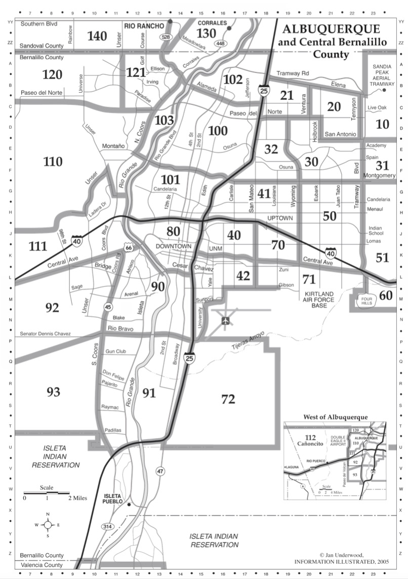
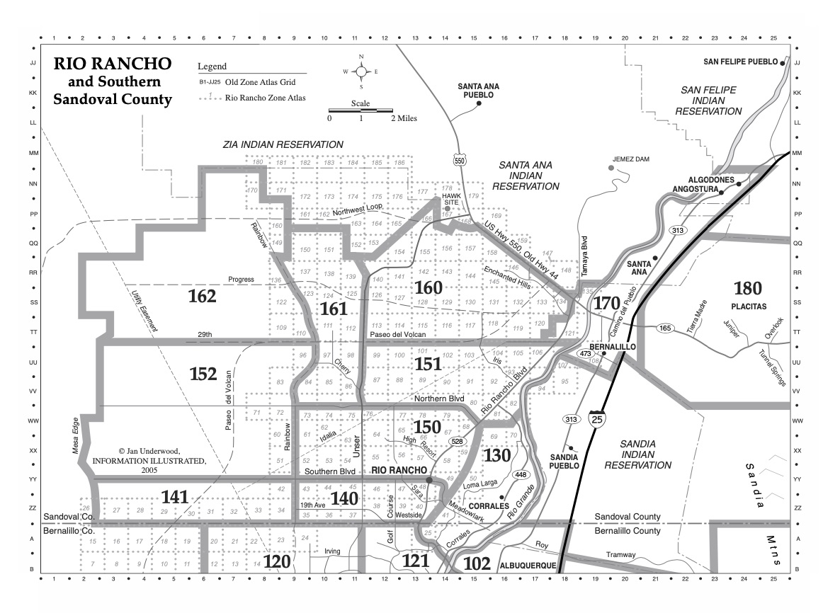
MLS Area Map
The Albuquerque MLS Area Map breaks down the city into geographical sections. The quadrants are officially part of the mailing address. They are NE (Northeast), NW (Northwest), SE (Southeast), and SW (Southwest). The north-south dividing line is Central Avenue, I-40 being the path Old Route 66 took through the city, and the east-west dividing line is the BNSF Railway tracks. Although this is technically the city’s division, Albuquerque residents often use the perpendicular interstates I-25 and I-40 to divide the city into four primary quadrants. For simplicity, this is how we, too, geographically divide Albuquerque. Scroll down to see the different MLS Area Map.
Northeast Quadrant:
The Northeast section of the Albuquerque MLS Area Map has been experiencing a housing expansion since the late 1950s. It abuts the base of the Sandia Mountains. It contains portions of the Sandia Heights, High Desert, and Glenwood Hills neighborhoods, which are situated in or near the foothills and are significantly higher, in elevation and price range, than the rest of the city. I-40 North and East of I-25 to the Sandia Peak Aerial Tram; this is the largest quadrant geographically and by population.
The Sandia Mountains are the predominant geographic feature visible in Albuquerque. “Sandía” is Spanish for “watermelon” and is popularly believed to reference the brilliant coloration of the mountains at sunset: a Pink-Purple hue. Other iconic locations include The Sandia foothills, the “Heights,” the Coronado and Winrock malls, Journal Center, and Albuquerque Academy are all in this MLS Area Map quadrant.
Some of the most affluent regions of the city are located in the NE Albuquerque quadrant, including Academy Hills, Tanoan Country Club, High Desert, Glenwood Hills, and Sandia Heights. Large homes and lots are found in North Albuquerque Acres and Albuquerque Acres West.
Northwest Quadrant:
The Northwest MLS Area Map includes the most significant section of Albuquerque. The Rio Grande River and the Bosque (Cottonwood forest “woodlands” ) meander through the NW and North Valley. The notable Rio Grande Nature Center State Park can also be found here. The Petroglyph National Monument, Indian Pueblo Cultural Center, and Double Eagle II Airport are located here too. The rapidly-developing area on the west side of the river is commonly known as the “west side” and consists primarily of traditional residential planned subdivisions. The city is bordered on the north by the City of Rio Rancho and the Bernalillo/Sandoval County Line.
The Albuquerque Westside unveils some huge Master Planned communities in Paradise Hills, like Ventana Ranch, and well-established areas like Taylor Ranch.
The “North Valley” area, which includes some small farms, equestrian properties, and luxurious high-end residential homes along the Rio Grande, is located in this quadrant. The City of Albuquerque surrounds the Los Ranchos de Albuquerque Village and borders Corrales to the Northwest Valley.
Southeast Quadrant:
The Southeast Albuquerque MLS Area Map outlines Kirtland Air Force Base, Sandia National Laboratories, the University of New Mexico, the Central New Mexico Community College main campus, the Albuquerque International Sunport, University Stadium, Isotopes Park, and University Arena (“The Pit”) are located in the Southeast (SE) quadrant. The Nob Hill and East Downtown neighborhoods lie along Central Avenue.
Recent developments in the Southeast neighborhood, such as the Cesar Chavez Community Center and Veterans Memorial, have shown that this area is in the beginning stages of reestablishing itself as one of many cultural centers in the city. The older residential developments of Four Hills, Willow Wood, and Ridgecrest are also located in this quadrant, while Mesa Del Sol and Juan Tabo Hills offer newer homes.
Southwest Quadrant:
Traditionally consisting of agricultural and rural areas, the Southwest quadrant of our MLS Area Map is often called the “South Valley.” Although the city limits of Albuquerque do not include all of the regions, the South Valley is considered to extend South to the Isleta Indian Reservation. The SW MLS Area also comprises Downtown-Old Town, Near South Valley, Southwest Heights, and Valley Farms sub-communities. The south end of downtown Albuquerque and the Bosque (“woodlands” cottonwood forest), the historic Barelas neighborhood, The Country Club community, the National Hispanic Cultural Center, the Rio Grande Zoo (which is part of the City’s Albuquerque BioPark system), and Tingley Beach are also located here.
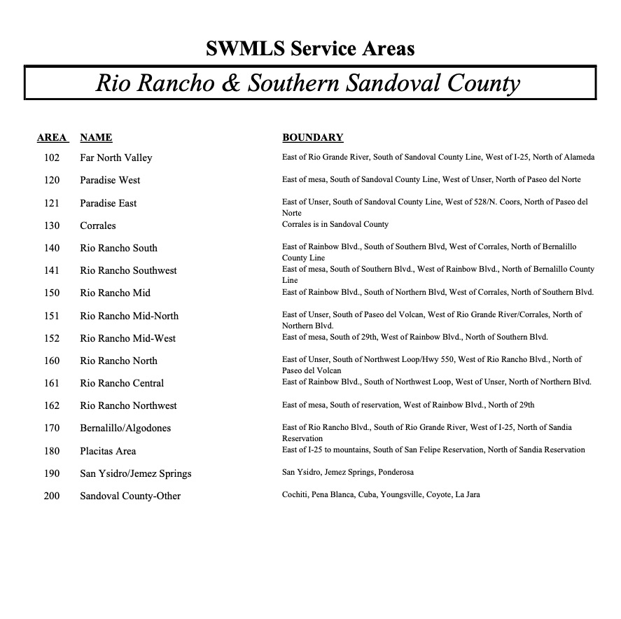
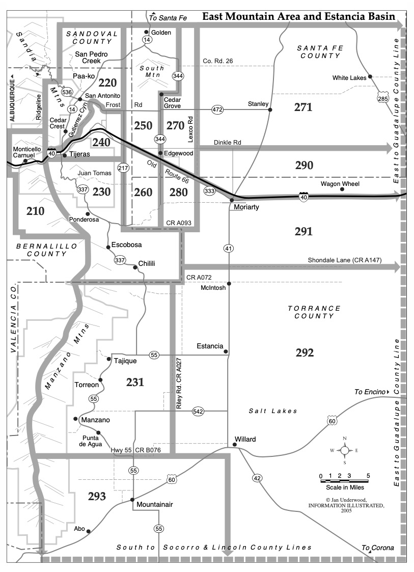
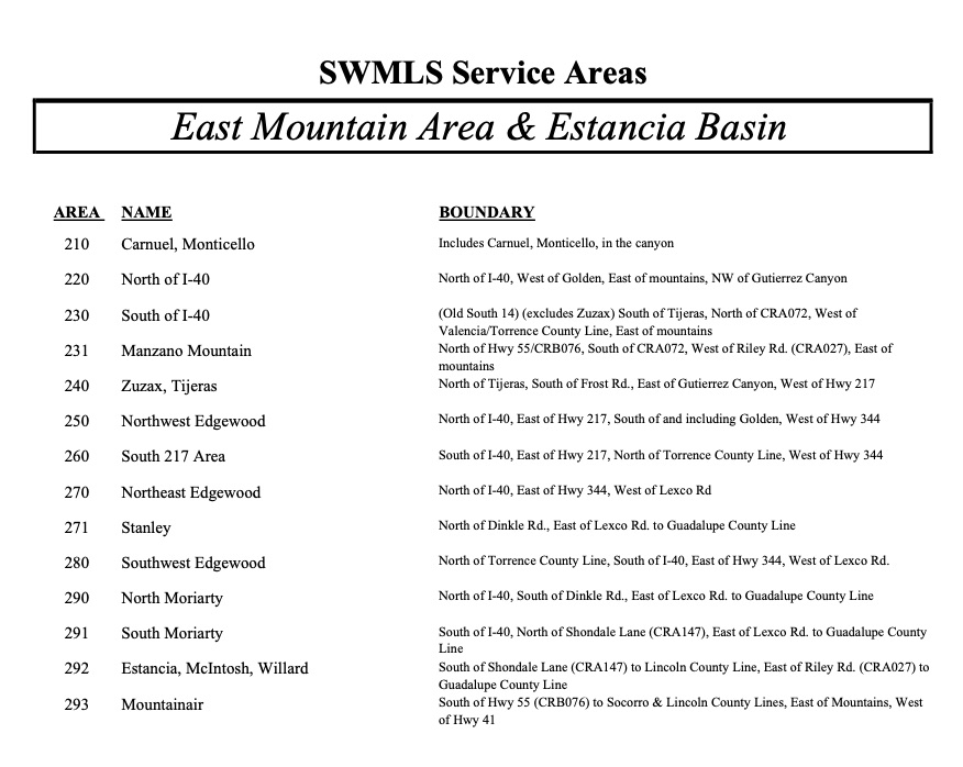
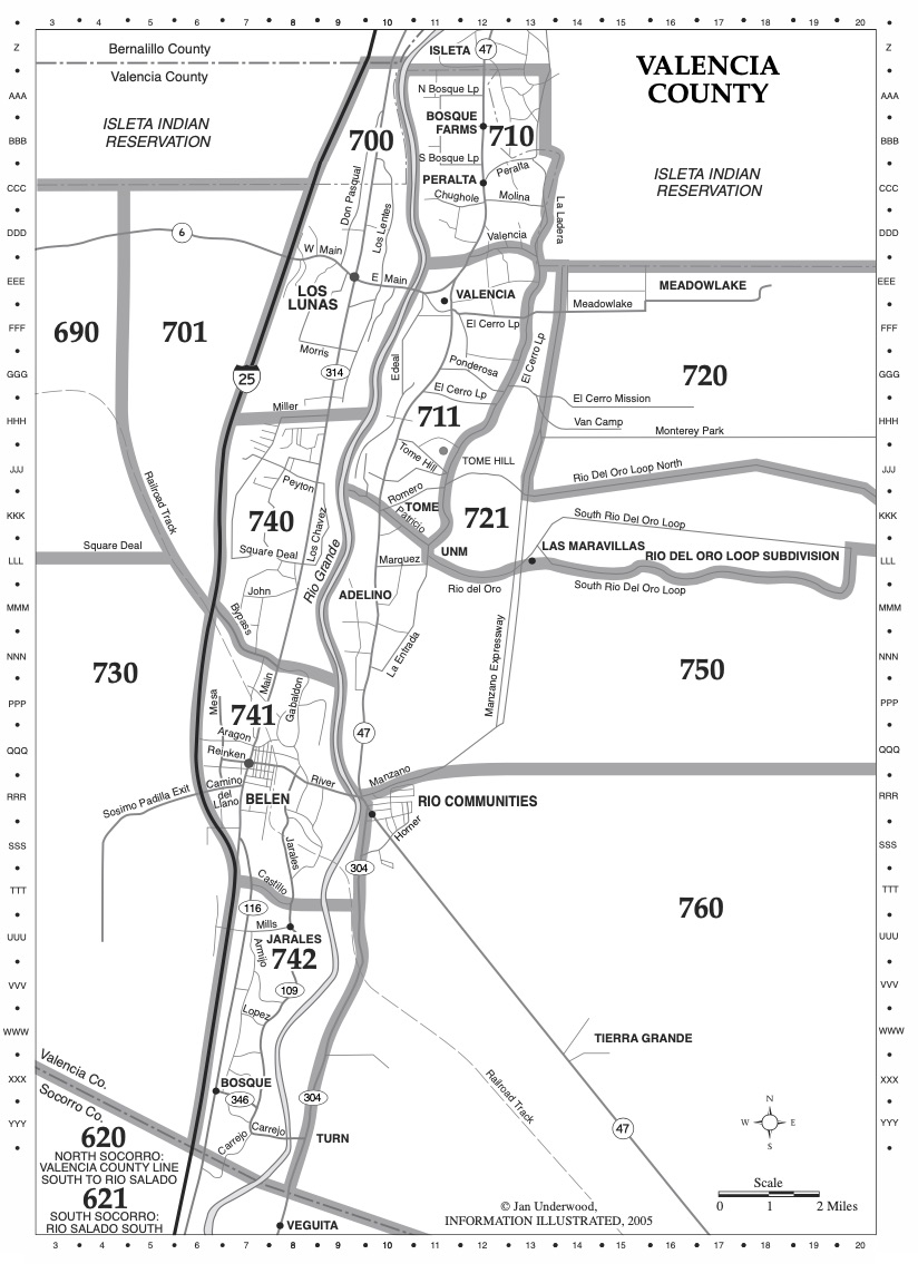
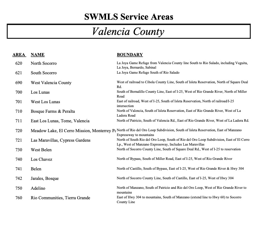
The Albuquerque MLS Area reaches far beyond just the four corners of the City of Albuquerque. The MLS also covers the towns of Rio Rancho, Bernalillo, Corrales, and Placitas, plus the East Mountain communities of Tijeras, Cedar Crest, Paako, and Sandia Park. Edgewood, NM, is also inclusive, as are Los Lunas, Bosque Farms, and Peralta communities, located South of Albuqueuerq in Valencia County.
We have only touched on the many areas, communities, and neighborhoods available in the Albuquerque Metropolitan area. Here at Albuquerque Homes Realty, we know the Albuquerque, Rio Rancho, and surrounding NM areas well. We can help you find your dream home, land, or investment property. We make it simple, contact us, tell us what you’re looking for, and let our experience and knowledge of the area be the beginning of your home search success.
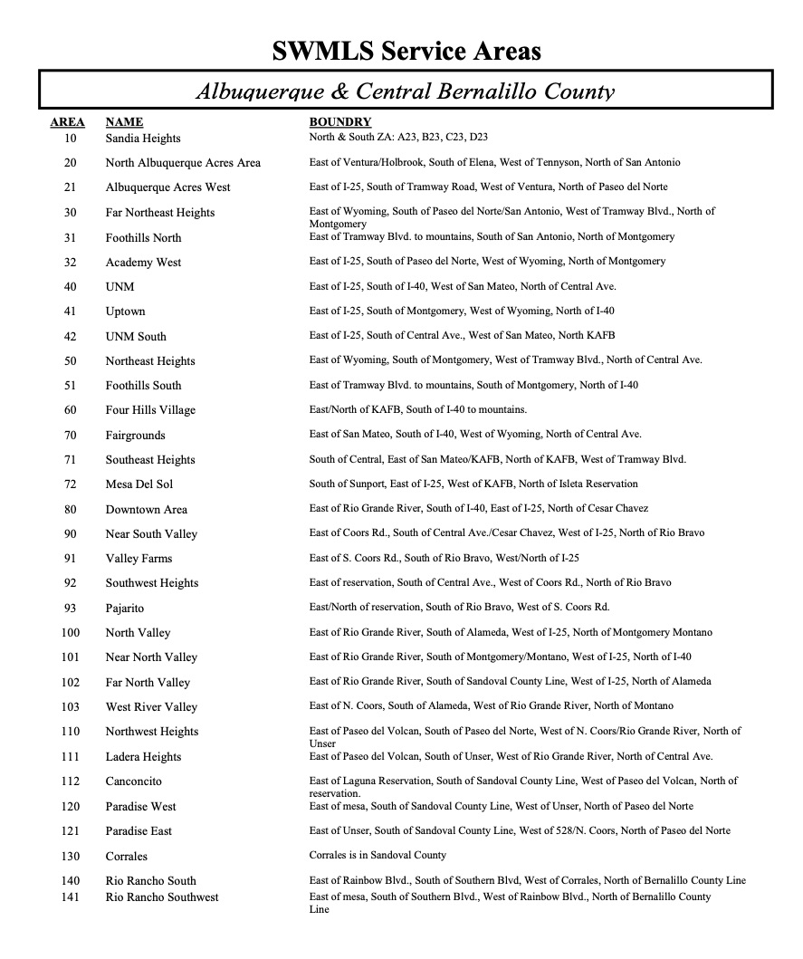
The MLS Area map
The MLS Area map further divides the city into smaller subsections to better subdivide different areas into more manageable quadrants. Use the MLS Area Map and corresponding list to help understand and best relate geographically to these areas.